Land and natural resource mapping by San Communities and NGOs: experiences from Namibia (PLA 54)
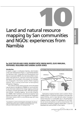
Julie Taylor and Carol Murphy, Simon Mayes, Elvis Mwilima, Nathaniel Nuulimba and Sandra Slater-Jones share their experiences, including the opportunities and threats, of mapping the San territories in the Caprivi Region of Namibia. PGIS practice often evolves to address specific issues being faced by a community. This means that multiple tools might be used together, or in sequence to deal with those issues. They note the potential of PGIS practice to expose and address the complex and politicised issues of identity, rights and land. They further identify how these maps can have multiple applications, including the strengthening of local rights and capacity to manage an environmentally important conservation area.
Participatory Learning and Action (PLA, formerly PLA Notes) is the world's leading series on participatory learning and action approaches and methods. PLA publishes articles on participation aimed at practitioners, researchers, academics and activists. All articles are peer-reviewed by an international editorial board. See: www.planotes.org
Article in: PLA 54. Guest-edited by: Giacomo Rambaldi, Jon Corbett, Michael K. McCall, Rachel Olson, Julius Muchemi, Peter Kwaku Kyem, Daniel Wiener, Robert Chambers
Keywords: mapping, Participatory Geographic Information Systems (PGIS), PPGIS, Geographic Information Technologies and Systems, geo-spatial information management tools, sketch maps, participatory 3D models (P3DM), aerial photographs, satellite imagery, Global Positioning Systems (GPS), Geographic Information Systems (GIS), software.
To read the full table of contents or download whole issue please click on More information above.
Cite this publication
Available at https://www.iied.org/g02953